State University of New York
a service of the Polish Academic Information Center
|
Poland on the Web |
| University at Buffalo State University of New York |
Annotated links to Poland-related information a service of the Polish Academic Information Center |
NAVIGATION
Home
 Geography
Regions
Geography
Regions
|
SEARCH |
 Małopolska (Little Poland) Małopolska (Little Poland) | |||
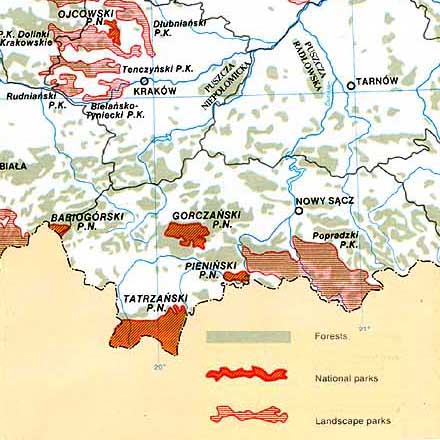
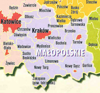
Although Małopolska is the name of one of Poland's 16 administrative provinces (Fig 1), historically the area associated with this name was significantly larger (Fig 2) stretching from Czestochwa in the west to Lublin in the east and encompassing the land between this line and the mountain ranges that form Poland's southern border. North of the mountains, it's a region of gently rolling hills and green valleys. In ancient times, the Vistulans, a Slavic tribe, lived along the upper Vistula River basin near Kraków. Kraków itself became the Poland's capital in 1038 with the royal residence being located on Wawel hill overlooking the town. One can still see on the hill the remains of a 10th century church. Evidence of even earlier settlement include the remains of a pagan tample discovered by archeologists in the town's main square under the foundations of the 10th century Church of St. Wojciech (Adalbert). In more recent times, namely during the periods of the partitions (1795-1914), Małopolska was part of Galicia, the Austrian province. Since Austrian rule was more relaxed than either that of the Prussian/Germans or the Russians, Małopolska became the location where Polish patriotism found most explicit expression. NOTE: Separate webpages cover the two southmost regions of Malopolska, Podhale and the Tatra Mountains and The Pieniny Mountains | |||
| For notes on other regions check out Annotated Listing of Poland's Regions | |||
Mapservers
| |||