State University of New York
a service of the Polish Academic Information Center
|
Poland on the Web |
| University at Buffalo State University of New York |
Annotated links to Poland-related information a service of the Polish Academic Information Center |
NAVIGATION
Home
 Geography
Regions
Geography
Regions
|
SEARCH |
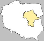
 Mazowsze Mazowsze | |
Mazowsze Province The Province covers an area of 35,597 square kilometres and is the largest administrative region of the country. The area accounts for 11,4% of Poland's territory. Mazovia lies in the center of Polandin the great central plain between the Warta and Vistula Rivers. From the west the Province borders on Kujawsko-Pomorskie and Lodzkie Provinces; from the north on Warminsko-Mazurskie, from the east on Podlasie and Lubelskie, and from the south on Swietokrzyskie Province. The Mazovians occupied the land between the Bug and Vistula Rivers. During the 15th and 16th centuries this tribe migrated to the forests of western Lithuania, particularly to Podlasie, and some others settled in the Duchy of Prussia, which was the Mazurian Lake district, located to the north of Mazovia. | |
| For notes on other regions check out Annotated Listing of Poland's Regions | |
Mapservers
| |